Units (R3UNITS)
Command: R3UNITS
Opens the R3Survey unit settings dialog. These settings control how distances, areas, and angles are entered and displayed across all R3Survey commands.
See Units for a full explanation of unit types and conversion factors.
The three unit concepts
| Concept | Meaning |
|---|---|
| Drawing units | What one model-space unit represents (e.g. 1 drawing unit = 1 metre). This is the internal storage unit. |
| Input units | The unit you type in R3Survey commands (e.g. feet and inches). R3Survey converts to drawing units automatically. |
| Display formatting | How values are shown in the UI, R3PROPERTIES, and annotation. Display settings never change stored geometry. |
These are independent. You can draw in metres, enter distances in feet and inches, and display results in links — R3Survey converts everything automatically.
Form tabs
The dialog has four tabs: Length, Angles, Area, and Custom Units.
Length tab
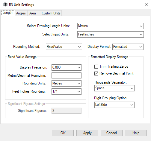
Drawing Length Units
Defines what one model-space unit represents (e.g. metres, feet, links, US survey feet). Set this to match your drawing.
Input Units
The default unit used when entering distances in R3TRAV and R3OFFSET. Can also be switched dynamically during those commands (m, f, e, u, l).
| Unit | Description |
|---|---|
| Metres | SI metric |
| Feet and inches | Imperial, entered in feet.inches-numerator/denominator format |
| Decimal feet | International feet, decimal |
| US survey feet | US customary feet |
| Links | Survey chains (1 chain = 100 links = 20.1168 m) |
| Custom | User-defined conversion factor |
Display settings
- Display precision — number of decimal places shown in the UI
- Metric/Decimal rounding — rounds displayed values (set to 0 to disable; e.g.
0.005rounds to nearest 5 mm) - Rounding units — the unit the rounding value is expressed in
- Feet & Inches rounding — rounding fraction for displayed feet and inches values (e.g. nearest ¼ inch)
- Trim trailing zeros — removes trailing zeros (e.g.
35.500→35.5) - Rounding method — fixed rounding value or significant figures
Display precision and traverse entry
When entering the next traverse leg, R3TRAV pre-fills the previous distance using the current display precision. Accepting that pre-filled value creates the leg at the displayed (rounded) value. Set display precision to match the number of decimal places you need for input.
Angles tab
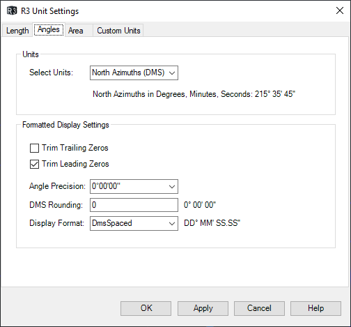
Angle Units
Choose the format for bearing entry and display:
| Option | Format | Example |
|---|---|---|
| North Azimuths (DMS) | Whole-circle, degrees-minutes-seconds | 215°35'45" |
| Surveyor's Bearings | Quadrantal (N/S toward E/W) | S 45°21'35" E |
| Gradians / Gons | Whole-circle, 400g per revolution | 385.7184 g |
| Decimal Degrees | Whole-circle, decimal | 215.8921° |
R3Survey uses its own angle engine and ignores AutoCAD's UNITS angle settings.
Display Format
Controls how angle values are presented:
| Format | Example | Applies to |
|---|---|---|
| Compact | 215°35'45" |
DMS and Surveyor's Bearings |
| Spaced | 215° 35' 45" |
DMS and Surveyor's Bearings |
| Decimal | 215.3525 |
All angle types |
Other angle settings
- Angle precision — decimal places shown for seconds (or decimal degrees). Affects R3PROPERTIES, R3TRAV form, and all angle displays.
- Angle rounding — rounding applied to annotation outputs (bearing text placed in the drawing). Does not affect R3PROPERTIES or R3TRAV prompts. Set to
0to disable. - Trim trailing / leading zeros — controls zero trimming in displayed angle values.
Area tab
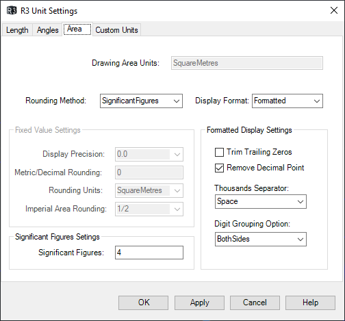
Display settings
- Drawing Area Units — automatically set based on drawing length units
- Display precision — decimal places for area values
- Metric/Decimal rounding — rounding for displayed areas (e.g.
1rounds to nearest m²) - Imperial Area rounding — rounding fraction for Acres/Roods/Perches display
- Trim trailing zeros, Thousand separators, Digit grouping — formatting options
Area units available include: square metres, hectares, square feet, acres, square chains, perches, and custom units.
Custom Units tab
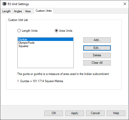
Define custom length and area units using a conversion factor relative to metres (for length) or square metres (for area). Any unit used anywhere in the world can be defined this way — historic units, regional systems, or project-specific units.
Custom units appear alongside built-in units in all input and display dropdowns.
Known issue
Editing a custom length unit resets the current input unit to metres. Set the input unit again after editing a custom unit.
Notes
- Unit settings are persisted between sessions
- Display unit changes in R3UNITS are reflected immediately in an open R3PROPERTIES panel
- Input and display units are independent — you can enter in links and display in metres simultaneously
- AutoCAD's LUNITS, ANGTYPE, ANGBASE, and clockwise/counterclockwise settings are ignored by R3Survey